Ishidatami Michi (石畳道) – Stone-Paved Road in Kinjo-cho, Shuri
Ishidatami Michi – Stone-Paved Road
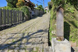
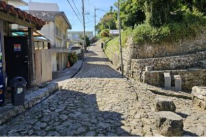
The Shuri Kinjo-cho Stone-Paved Path is a preserved section of an old road located in Kinjo-cho, Shuri, Okinawa, Japan. This stone path was once part of the Pearl Road, a major route during the Ryukyu Kingdom era that connected Shuri Castle to the southern regions of the island.
History says the Pearl Road began at a stone gate on the southeast side of the Shureimon Gate, within the grounds of Shuri Castle. From there, it descended through Kinjo-cho, passed Kinjo Ufugaa, crossed Kanagusuku Bridge, continued past Shikina Garden, and reached Madan Bridge over the Kokuba River. The route ended at Naha Port, covering a total distance of about 10 kilometers.
Ishidatami Michi – Stone-Paved Road
The section that remains today in Kinjo-cho is approximately 300 meters long and built from Ryukyu limestone. The surface can be rough and slippery when wet. Despite heavy destruction during the 1945 Battle of Okinawa, this part of the road and the surrounding area survived. The original stones still line both the street and the nearby house foundations.
The Madan Bridge area, once a key crossing point on the road, marked a shift in direction as the route turned southwest toward the Shimajiri District. While most of the road was destroyed by Allied forces, the preserved stretch in Kinjo-cho remains one of Okinawa Prefecture’s most important historical landmarks, representing the architectural and cultural legacy of the Ryukyu Kingdom.
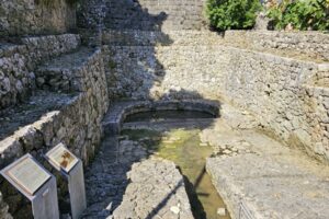
Kinjo Ufugaa
“Kinjo Ufugaa”, or “Kanagusuku Ufuhija” in the Okinawan dialect, means “Large Spring at Kanagusuku.” Kanagusuku is the Okinawan pronunciation of Kinjo (金城), the area where the spring is located. “Ufuhija” comes from ufu meaning “large” and “hija” meaning “spring” or “water source.”
Kinjo Ufugaa – Large Spring at Kanagusuku
The Kinjo Ufugaa is a hija (樋川), a spring where water is drawn through a toi (樋), a horizontal channel that leads water from a vein deep in the bedrock. This differs from a kaa (カー), a vertical well where water rises naturally from surrounding sources.
Before homes had running water, this hija served as the village’s communal well. Villagers carried water daily in buckets for household use. The spring stands as a reminder of a time when water had to be fetched by hand and used carefully.
The stonework around the spring uses the aikata (相方積み) method, an interlocking style common in Okinawan construction. In front of the spring is a stone-paved area called kaanunaa. History tells that the surface has been worn smooth, and the edges rounded, from years of people walking and standing there while collecting water.
Where did I get all that information from? It was on the signs at the well, based on local accounts.
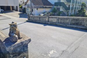
Kanagusuku Bridge
The sign beside the bridge tells us the following story:
Kinjo Bridge
Kanagusuku Bridge was built during the Ryukyu Kingdom era and spans the Kanagusuku River flowing through the Kinjo area of Shuri. The exact date of the original construction is unknown, but it is recorded that a wooden bridge was rebuilt in 1677 using stones from the former structure (referred to as Shitenbashi).
Due to flood damage in 1809, the bridge was reconstructed in 1810, slightly downstream from its original location. A stone marker was placed on the south side of the bridge bearing the inscription “Jushu Kanagusuku-bashi Hihun” (寿手金城橋碑文).
The bridge was destroyed in the 1945 Battle of Okinawa, and only parts of the stone marker remained. During reconstruction in 1985, the marker was relocated to the north side of the bridge, where it still stands today.
From Kanagusuku Bridge, the slope that leads to Shikina Garden is known as “Shichanabira”. This term is a local name for Shikina-no-hira, meaning “Shikina slope”. The path had beautiful paving stones lined with pine trees, forming a royal path leading to the Shikina Detached Palace, a retreat for the royal family. It was also a shortcut from Shuri to Shimajiri and served as a route for sending messages.
In the nearby cave, there is a legend of a sea deity. Sailors would carve ship images into the cave wall and pray for a safe journey. Another story, “The Ghost of Shichanabira”, tells of a couple who threw themselves into the river and became spirits, forever floating on the surface in sorrow.
Madan Bridge Ruins
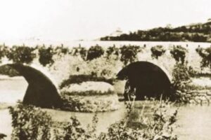
Madan Bridge around 1930
Madan Bridge was built in 1522 (the first year of the Jiajing era) to link Shuri and the Shimajiri region. Its center was a five‐span wooden bridge called Madan Bridge. The span to the south was Yomochi Bridge, the span to the north was Yoyori Bridge, and the outer two spans had no names.
They began rebuilding it in stone in 1707 (the 46th year of the Kangxi era) and completed the work the next year. In 1837 (the 17th year of the Daoguang era), they rebuilt Yoyori Bridge and added a new span north of it called Seisai Bridge, creating a six‐span stone bridge.
Madan Bridge had graceful arches and “sūchiri” cutwaters at its piers to protect it from flowing water. It showed the best of Okinawan stone‐bridge design. Allied forces destroyed it during the Battle of Okinawa in 1945.
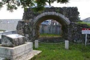
Madan Bridge Ruin
In 1996, excavation for a postwar repair project uncovered parts of the original stone bridge on both the Tomigusuku and Naha sides. Local residents campaigned to preserve and use the restored sections. On the Tomigusuku side, they moved and rebuilt the best‐preserved arch under the road and covered the rest for protection.